By Kendra Pierre-Louis
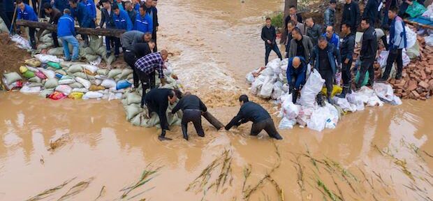
Torrential rainfall from Typhoon Doksuri inundated Beijing on Monday, flooding neighborhoods, damaging roads and killing two people. Parts of the city saw up to three inches of rain, just over half of what Beijing usually gets in all of July. While it’s too soon to determine whether Typhoon Doksuri was made stronger by climate change, higher temperatures are raising the odds of more intense precipitation around the world — and the dangers that come with it.
So far this year, rain-induced flooding has hit regions that include India, the Philippines and California and Vermont in the US. Last August, after flooding killed 1,700 and displaced 8 million in Pakistan, researchers at World Weather Attribution were able to calculate that climate change made the rainfall 75% more intense. When Hurricane Ian hit Cuba and Florida a month later, researchers estimated that climate change had made its rainfall 10% worse.
As temperatures increase, so too does evaporation — a relationship familiar to anyone who’s tried drying clothes outside in winter versus summer. That’s because warmer air is able to absorb more water; and as evaporation increases, precipitation does too. “That means that globally, there’s going to be more precipitation,” says Anthony J. Broccoli, a professor of atmospheric sciences at Rutgers University and co-director of the Rutgers Climate Institute.
For every 1 degree Celsius the atmosphere warms, it holds 7% more water vapor. So far, the Earth has warmed by roughly 1.3C, and current projections from Climate Action Tracker anticipate global average temperature increasing about 2.7C by 2100.
But understanding precisely how the added evaporated water in the atmosphere and subsequent precipitation will be distributed remains elusive, Broccoli says, because the “models don’t do as well with projecting changes in precipitation” as they do changes in temperature.
Those models rely on both weather records going back to the 1800s and paleoclimate data that predates temperature records, from things like ice core samples and tree rings. That wealth of data shows relative consistency in global average temperatures, but significant variation in precipitation — which makes parsing the role of climate change in rainfall more difficult.
“Precipitation is probably changing every year in response to warming,” says Upmanu Lall, the director of the Columbia Water Center at Columbia University and the chapter lead on the 2018 National Climate Assessment’s chapter on water. “But the historical variation in precipitation is so large that we don’t really see clear signals on site data.”
The signals scientists have been able to parse are concerning. The NCA’s water chapter notes that “heavy precipitation in most parts of the United States has increased in both intensity and frequency sine 1901 and are projected to increase over this century.”
Rainfall from convective storms, for example, which includes many thunderstorms, is likely to increase in coming years. Convective storms are concentrated in the Northern Hemisphere near the tropics but also occur elsewhere. They happen when heat and moisture are transported vertically into the atmosphere.
Lall points to the classic midwestern storm in the US as an example. As the day warms, water from irrigated fields, rivers and lakes evaporates. That air rises because hot air rises, forming clouds. When those clouds encounter the cooler upper atmosphere — temperatures drop roughly 2C with every 1,000 feet of elevation — they cool, too. And because cooler air can’t hold as much water, it rains. As the climate warms, the air that rises gets warmer, meaning it holds more water and can yield more intense rainfall when it hits the upper atmosphere.
“We expect flash floods from that kind of situation,” Lall says. “If you read the literature on this, people will talk about how the intensity of hourly rainfall has gone up a lot in the last 20 or 30 years. And that’s strictly going to be related to the convection mechanism.”
Other regions get their rainfall from more complex phenomena, including monsoons (wind-induced wet seasons) and atmospheric rivers (bands of water vapor that form over the ocean and flow through the sky). It can be difficult to suss out exactly how precipitation will evolve in these locales, in part because climate change is altering the circulation of atmospheric currents. But one thing researchers are already seeing is more variability in the water cycle.
“We may get heavier rains when it does rain, but also longer dry spells between rain events,” Broccoli says. “As the temperature goes up, there’s more rapid evaporation. Then during the dry periods, things will dry out more quickly.” In Maine, for example, farmers who used to rely on rain to water their crops are finding they have to invest in irrigation as summers become drier. When rain does fall, it’s more intense.
Communities facing more volatile precipitation will have to prepare. To mitigate flooding risk, municipalities can remove or reduce impermeable surfaces like roads and replace them with permeable surfaces like rain gardens or permeable concrete. Some of those solutions have the added benefit of being effective at combating heat.
“There’s some potential ways to mitigate several types of risks at once,” says Elizabeth Sawin, founder and director of the nonprofit Multisolving Institute. Sawin says she once worked with a sewage district commissioner in Milwaukee who described such mitigation as “softening the city.”
“Those words always stuck with me,” she says.
But even the best adaptation options still have limits. “If you get a month’s worth of rain in a day, more plants and more permeable parking lots can only do so much,” Sawin says. “So it’s not a panacea. It has to go hand in hand with getting our societies off fossil fuels.”
To contact the author of this story:
Kendra Pierre-Louis in New York at kpierrelouis@bloomberg.net
© 2023 Bloomberg L.P.